276
OpenStreetMap community
5213 readers
5 users here now
Everything #OpenStreetMap related is welcome: software releases, showing of your work, questions about how to tag something, as long as it has to do with OpenStreetMap or OpenStreetMap-related software.
OpenStreetMap is a map of the world, created by people like you and free to use under an open license.
Join OpenStreetMap and start mapping: https://www.openstreetmap.org/.
There are many communication channels about OSM, many organized around a certain country or region. Discover them on https://openstreetmap.community/
https://mapcomplete.org/ is an easy-to-use website to view, edit and add points (such as shops, restaurants and others)
https://learnosm.org/en/ has a lot of information for beginners too.
founded 6 years ago
MODERATORS
277
278
279
280
67
2024: announcing the year of the OpenStreetMap vector maps | OpenStreetMap Blog
(blog.openstreetmap.org)
281
19
OSM Teams is a tool for creating teams and roles in the #OpenStreetMap ecosystem for management of groups and communities to organize around existing tools like Tasking Manager, OSMCha, or iD, and improves collaboration.
- Found or find a team: https://mapping.team/teams
- Video demo: https://www.youtube.com/watch?v=GSa4IWxZz4g

282
283
284
Unfortunately the OSM website has a limit to how many it can show you at once and it shows the most recently updated ones, so you can't see how many unclosed notes still exist.
One of them is over five years old and requires on-site verification, so I know what I'm doing this weekend!
285
286
287
51
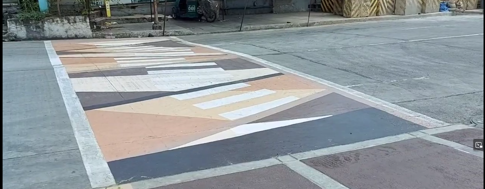
A nearby city call these crossings as "Gora¹ Lanes", an attempt to make walking fun, attractive, and accessible to more people.
(cdn.masto.host)
A nearby city call these crossings as "Gora¹ Lanes", an attempt to make walking fun, attractive, and accessible to more people.
From the screenshot² below, it's something like an arty zebra (or "continental") crossing, and I saw minimal use of crossing:markings=artwork in #OpenStreetMap, and taggable with crossing:markings=yes.
I wonder how you folks might tag it.
¹ - Gora is an acronym from "Green Open Reclaimed Access"
² - Source: screenshot, https://yewtu.be/lKMFjLcTVkQ?t=59
288
23
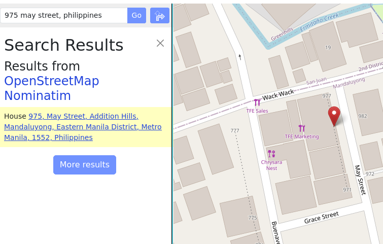
When mapping street addresses in #OpenStreetMap, the minimum tag you probably need is addr:housenumber and addr:street, or maybe addr:place.
(cdn.masto.host)
When mapping street addresses in #OpenStreetMap, the minimum tag you probably need is addr:housenumber and addr:street, or maybe addr:place.
In this example, house numbers 971 and 977 are the only two points actually mapped, and connected by a way tagged with addr:interpolation=odd.
The geocoder still returned the estimated position for the unmapped housenumber, 975.
Read about interpolation here: https://osm.org/wiki/Addresses#Interpolation
It's a quick method for adding street addresses in @openstreetmap
289
Have you been receiving unsolicited messages in your #OpenStreetMap inbox?
Well, it seems like this feature has been quietly introduced recently: "mute this user" link is now available for every @openstreetmap user page.

290
291
28
When editing #OpenStreetMap on the go, @everydoor is my hands-down favorite, but I'd hesitate recommending it for more new mappers.
(cdn.masto.host)
When editing #OpenStreetMap on the go, @everydoor is my hands-down favorite, but I'd hesitate recommending it for more new mappers.
I've been playing with #OsmGo just now, and really like how easy it is, maybe even for new contributors.
Plus, it's a progressive web app that runs in a browser, or installable in your device: https://osmgo.com , so this also seems to be a great candidate tool to introduce as a friendly editor for @openstreetmap mapping parties for new users.
292
-12
Organic maps which claims to be ad-free was marked by F-Droid as “Containing ads”
(discuss.tchncs.de)
293
295
296
297
298
299
300
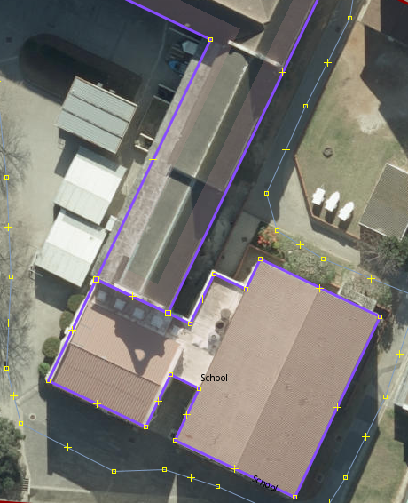
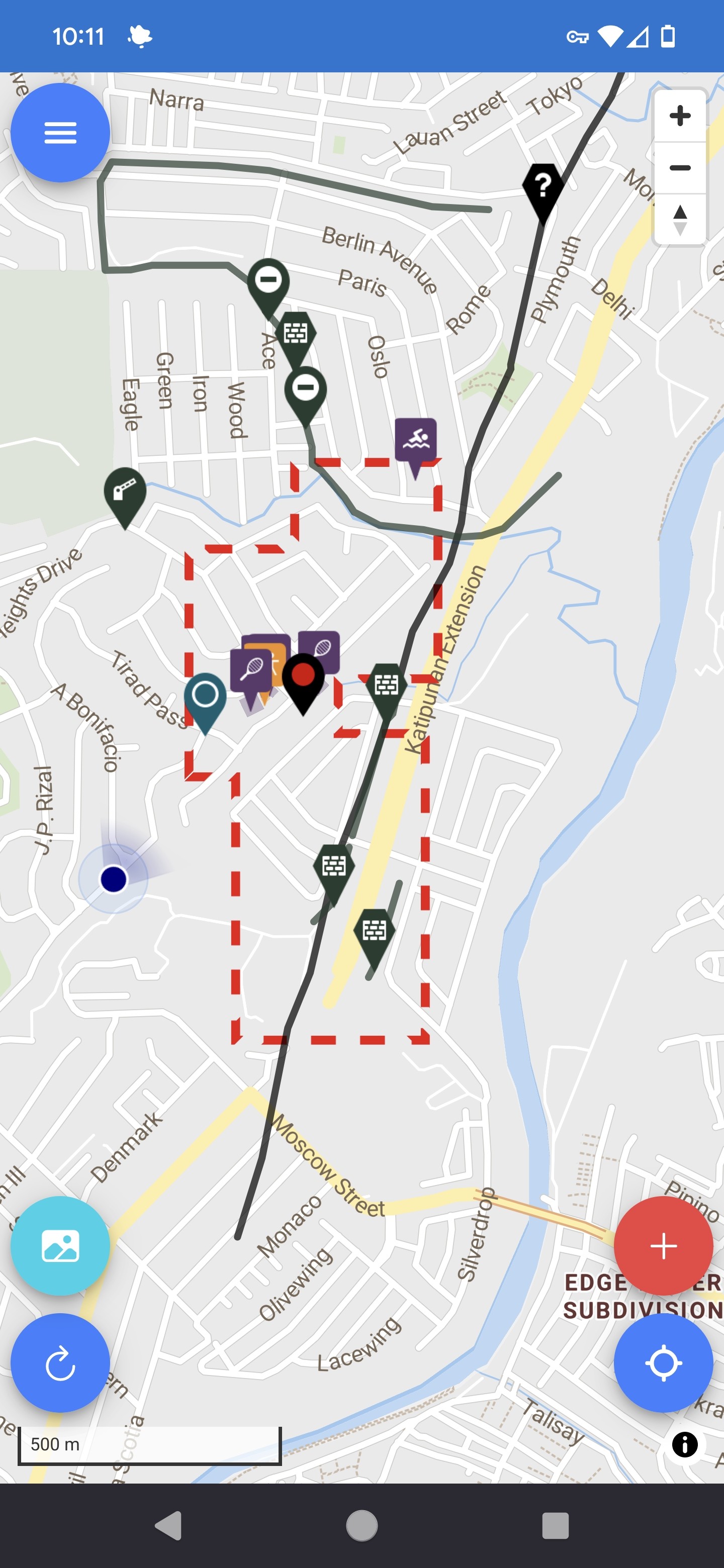
I was updating my old high school on OSM and noticed that whoever mapped it before used a multipolygon to map the buildings. From what I can tell the benefit to this is that you can map more complex shapes by having them be related, is that correct?^2^
There are some buildings that have been added as building=yes instead of building=school (some haven't been marked at all) and I want to make sure I understand it better before I go and make any big changes.
^1^ my old high school for context - Esri World Imagery has the best image quality once you zoom in.
^2^ My understanding comes from this wiki page
EDIT:
Some extra clarification as to why I'm asking. There are some buildings that have been added as separate multipolygons which don't make sense to me. (see screenshot), these two buildings were added as separate multipolygons but they are connected and form part of the same building.
I also get a warning in JOSM that says "amenity inside amenity - amenity=school inside amenity=school"