OpenStreetMap community

4424 readers
11 users here now

Everything #OpenStreetMap related is welcome: software releases, showing of your work, questions about how to tag something, as long as it has to do with OpenStreetMap or OpenStreetMap-related software.

OpenStreetMap is a map of the world, created by people like you and free to use under an open license.

Join OpenStreetMap and start mapping: https://www.openstreetmap.org/.

There are many communication channels about OSM, many organized around a certain country or region. Discover them on https://openstreetmap.community/

https://mapcomplete.org/ is an easy-to-use website to view, edit and add points (such as shops, restaurants and others)

https://learnosm.org/en/ has a lot of information for beginners too.

founded 5 years ago
MODERATORS
251


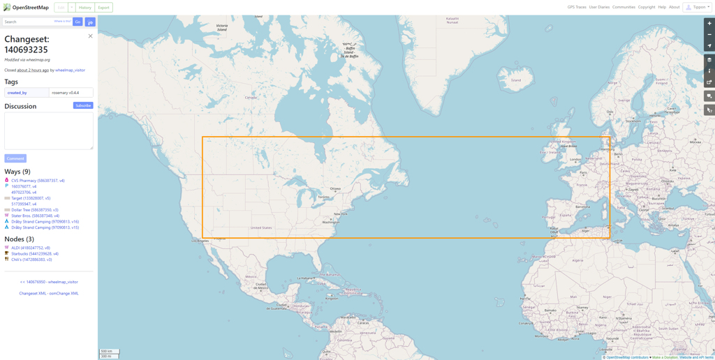
I've just opened the OSM site on my PC to have a look at the history in my area, and I've seen this apparently massive edit. It covers most of the US, a lot of Canada, and a significant chunk of Europe and the UK.

wheelmap_visitor says that 'This is a proxy user for all wheelchair tag changes happening on Wheelmap by anonymous users of the website and app Wheelmap.org.' so does this mean that if someone has made edits to areas inside the rectangle at some point recently that they all get included in this edit?

252


Is it possible to get a nice looking overlay? Like this one: https://www.ecosia.org/map?q=lunga&coordinates=56.488247,-6.422436&placeName=Isle%20of%20Lunga

Ecosia Maps are using OpenStreetMap but the definition is so much more pleasant to look at. OpenStreetMap or Organic Maps are a lot more...technical.

253


It's very annoying. :(

254
 
 
255


I'm a big fan of cyclOSM bike maps, that I use in OSMAnd. Now I wanted to try Locus. Bur how do I use cyclOSM maps in Locus. As far as I know I need to import a XML file. But with which content?

Could someone help me please?

Thanks in advance

256
257
258


Hi all :)

This is more of a curiosity question than anything else.

About two or three weeks ago, I added two buildings and the businesses inside them through the OSM website. I haven't had a chance to do anything else yet.

I installed Organic Maps earlier to try it out, but noticed that my buildings weren't there. I tried OSMAnd+ and Street Complete too, but they still weren't there. They are there in Every Door though.

Is this normal? Does it take a while for updates to filter through to apps, or have I done something wrong?

259


quite a few issues left but I'm hopeful it'll come soon!

260


I want to know how many contributions the number 1 contributor (and other contributors as well) in my country has but I can't seem to find it anywhere.

261


In SF we have some really long bus lines, 6 miles long and a ton of stops. One of those lines has a part-time extension now - it runs to an underserved overground rail station. It's a very high-value extension but runs only on weekdays, not weekends.

Normally we have separate relations for the weekday route and the weekend route. But others built those routes. I help maintain the ones we have, but I can't think of any way to get iD to clone a relation.

Is anyone either in SF and wants to clone the 31-Balboa, or knows of a tool that can do this? I've looked at JOSM and simply couldn't figure it out. I'm happy to do the grunt work of extending the line; I just have no good starting point.

262


I'm sitting here, wondering how long it'll take until we have finally managed to complete the bloody farmland areas while there are highly developed countries where they barely have buildings or POIs...

I hope in Germany we'll have all the farmland covered in less than three years 🤤

263


Hello all, I have a question. I use https://overpass-turbo.eu/ for running queries on the OSM database. However, this is useful for running queries over a specific region. I'm interested in running queries over recent OSM changes.

For example, how can I run a query of this sort: "give me all changesets from the last X days that adds the following tag" ?

264
265


OpenStreetMap Foundation launched consultations on their strategic plan v2.

You can provide your ideas and inputs via the community forum or on the mailing list.

https://blog.openstreetmap.org/2023/08/18/for-community-consultation-osmf-strategic-plan-v-2/

#OpenStreetMap #OSMF cc: @openstreetmap

266


Exciting Update: Mapilio Now Integrated with OpenStreetMap iD Editor! 🌍

Dear Mappers,

🎉🎉 We're thrilled to share some exciting news 🚀 – Mapilio is now seamlessly integrated with OpenStreetMap's iD Editor! Your contributions on Mapilio are now easily accessible and editable through the iD Editor, making collaborative mapping more efficient than ever.

https://mapilio.com

@openstreetmap @openstreetmap@lemmy.ml @OpenStreetMapUS @OSM_Pontarlier
#osm #openstreetmap

267


I have a question about openstreetmap. Is it possible to go back in time and look at the state of the maps in the past?

I have been doing a lot of mapping in my hometown. It looks much better now compared to 2-3 years ago. I want to do a before-vs-after comparison, but I forgot to take a "before" screenshot. Is this something I can do after the fact? Would it be possible to see what OSM looked like in 2020?

Thanks!

268
269


I am a regular Osmand user, but I don't know much about how OSM works in detail. I noticed that in some services that use OSM, addresses appear like in this screenshot.

This second part of the address often has interesting names that I've never heard even for places I know well.

To me it looks like the name of a Gemarkung or something similar.

  • What's the correct term for this part of an address?
  • Where is this data derived from?
  • Is it possible to show a map with the borders of these Gemarkungen (or whatever it is called)?

Also glad if someone can point me to the docs where I can read about this. I browsed the wiki but couldn't find what I was looking for.

Also interested about the correct terms for the other parts of the addresses.

Thanks!

270


Hi!

I'm the main dev of https://mapcomplete.osm.be (and also one of the modsof this subcommunity). I have a long train journey ahead of me today (and next week again).The ideal moment to answer questions from other OSM-contributors.

So, shoot!

271


I discovered StreetComplete recently and have been having fun "popping" quests around town, on vacation and around home. Now what? What happens with my contributions? How long before they're wrapped up into a map update? Do other people have to solve the same quest as a double check?

272


MapComplete wants to change domain and asks users for suggestions.

273


Archived version: https://archive.ph/hguLn

Excerpt (and context):

Apple Maps’ offering might surprise people who remember its disastrous launch in 2012, which the Guardian described as the company’s “first significant failure in years”. Users were more than furious – they were lost, sometimes dangerously so. In Australia, police had to rescue tourists from the huge Murray-Sunset national park, after Maps placed the city of Mildura in the wrong place by more than 40 miles. Some of the motorists located by police had been stranded for 24 hours without food or water. In Ireland, ministers had to complain directly to Apple after a cafe and gardens called “Airfield” was designated by the service as an actual airport.

But mostly the map was just glitchy and unhelpful, its directions always a little off kilter. Users revolted and Apple made a rare retreat, allowing Google Maps to be used as the default on many iPhone apps and apologizing for the product.

274


Starting today, the OSMF will be conducting an online fundraising campaign to support the future of OSM.

275


#OpenStreetMap Belgium’s Mapper of the Month #MotM is @joost_schouppe.

If the name sounds familiar to you, it might be for many reasons. It could be for his past involvement as OpenStreetMap Foundation #OSMF board member, for leading the Belgian community chapter, or being a very active mapper.

Read the interview at https://openstreetmap.be/en/motm/2023/08/01/joost-schouppe.html.

cc: @openstreetmap

view more: ‹ prev next ›