OpenStreetMap community

5223 readers
1 users here now

Everything #OpenStreetMap related is welcome: software releases, showing of your work, questions about how to tag something, as long as it has to do with OpenStreetMap or OpenStreetMap-related software.

OpenStreetMap is a map of the world, created by people like you and free to use under an open license.

Join OpenStreetMap and start mapping: https://www.openstreetmap.org/.

There are many communication channels about OSM, many organized around a certain country or region. Discover them on https://openstreetmap.community/

https://mapcomplete.org/ is an easy-to-use website to view, edit and add points (such as shops, restaurants and others)

https://learnosm.org/en/ has a lot of information for beginners too.

founded 6 years ago
MODERATORS
226
227


it's a bit rough in the ui/ux department and requires a google account but i had fun testing it today. you walk around to "produce" badges, which you can then "drop" wherever you are to make claims on map quadrants

found via https://weeklyosm.eu/archives/17334

228


I'm adding a business that is primarily for surfing and also has some skateboard accessories. Can I use multiple tags to designate this?

"shop=surf;skate"

Would that work? On the OSM wiki it says under cuisine you can use multiple tags but I don't see anything saying if it's proper to do that with a key for shop.

229


Blitzer.de Pro App is the bestseller App in German Play Store. The Update now features OpenStreetMap Slippy Map to show crowdsourced speed cameras, constructions, road closures and traffic jams. The App even has an OpenStreetMap based Navigation System.

1 Million people in Germany can now see and use OpenStreetMap Data in their App. This is a huge success and a breakthrough for OpenStreetMap adaption.

Unfortunately the app does not mention the Copyright yet. Hopefully this will be fixed soon.

230
23
submitted 1 year ago* (last edited 1 year ago) by darkham@lemmy.ml to c/openstreetmap@lemmy.ml


Edit: Imagine Google streetview for OpenStreetMap, this is Panoramax. https://panoramax.fr/ https://wiki.openstreetmap.org/wiki/Panoramax

The free alternative to photo-mapping territories Panoramax is a digital resource for sharing and exploiting field photos. Anyone can take photographs of places visible from the public highway and contribute them to the Panoramax database. This data is then freely accessible and reusable by all.

During State of Panoramax panel at State of the Map France 2024, they announced a alpha/beta version for Android Panoramax application. Apk for android is available with the link and will be published on PlayStore and F-Droid. iOS users don't worry a version will be available too.

231
 
 
232
19
submitted 1 year ago* (last edited 1 year ago) by gkpy@feddit.org to c/openstreetmap@lemmy.ml


18-21 July in Łódź, Poland

233
234
235


Since my last anti-war post (in the broad, global, universal sense; and narrow sense of our project) had been included some comments about the dove, I've created an orthodox version a'la Pablo Picasso from 1949 😁 Whoever wants it, can use it! (I must say in general that the OSM logo is outstanding in its universality - and this magnifying glass as a symbol of search - sweetness 🍯💪 ). @openstreetmap@lemmy.ml @openstreetmap

236
237


OpenStreetMap Community for Peace - logo for free use. @openstreetmap @openstreetmap@lemmy.ml

238


I'm seeing fake roads everywhere, and the map looks like a spider's web.

It's like this on every website that displays the cycleOSM layer: the official cycleOSM site, Openstreetmap, brouter, etc.

239
7
submitted 1 year ago* (last edited 1 year ago) by diy@sh.itjust.works to c/openstreetmap@lemmy.ml


I downloaded a map from geofabrik.de and got it as a pbf can I somehow convert it to a PDF. Or is there a website where you can download OpenStreetMap as a PDF.

240


I stumpled upon an unmaintained list of used shop=* tags for Germany. Link: https://wiki.openstreetmap.org/wiki/Germany/Shops

Since there is https://taginfo.openstreetmap.org there is no need to have this page anymore, which is not updated since several years.

Anybody knows how to delete a page?

241


It improved slightly with opengl but it's still very slow to render offline maps after years.

242


Just wanted to share this since I didn't find anything on lemmy about this. It's a pretty cool open-source project that I got introduced to while investigating a google maps / mapbox open-source alternatives for globe representation on the web.

Sorry if it doesn't fit into this community - didn't find a better community to post this and the sidebar says "OSM related software" posts are ok.

Here is a link to their website with examples: https://www.openglobus.org/

243
 
 
244


Presentation (in German) about OpenRailwayMap at GPN (Gulaschprogrammiernacht).

245


Answers accepted until June 6th. Gifts (a few months of osmand pro will be distributed by June 10th. Please, share among community!

246
48
submitted 2 years ago* (last edited 2 years ago) by governorkeagan@lemdro.id to c/openstreetmap@lemmy.ml


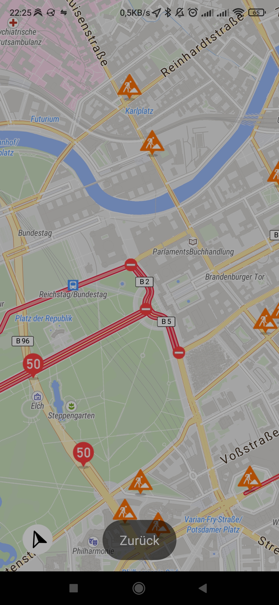
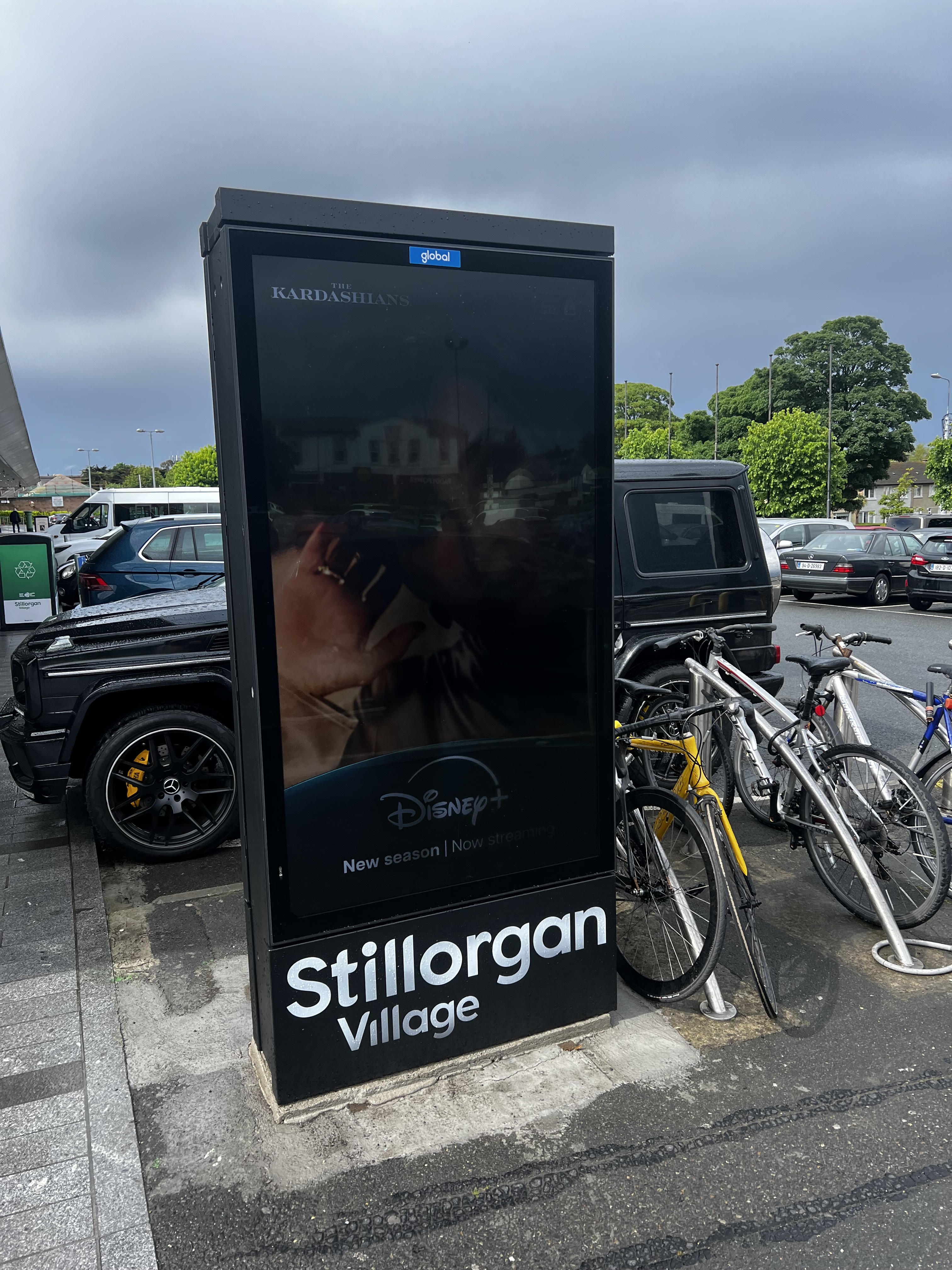
I’m referring to the advertising/digital display. I thought of using man_made=advertising + advertising=* but not of the examples on the wiki seemed to match very well.

EDIT:

I feel like an idiot for missing this but I found advertising=screen (1) after posting this

EDIT 2: Fixed the examples link

247


Edit: ~~the problem is gone, i assume it was a buggy track.~~ The problem exists with the versio 4.7.10, from 24.04.24, which is the version that is recommended by fdroid. It is gone in the latest one from 14.05.24

I updated osmand to 4.7.10 yesterday and now it seems like the little info widget on the bottom screen shows elevation (i assume), relative to the whole track, not the 10km that are currently shown in the widget. Cannot find anything in the settings. In the what's new it said they did some changes to the graphs but i could not make sense of it.

Does anybody know how i can set it back to the way it used to be, as in relative to current section of the track?

248
249


People are editing OSM to be able to get their Pokémon and others are changing OSM to mess with people so they can't get them

250


We are bringing @openstreetmap to #Wikimedia East, Southeast Asia & Pacific (ESEAP) 2024! 🗺️✈️🌏🇲🇾

Join us on Sunday, 12 May, 11AM at Mahua 1 Room to learn how to map in #openstreetmap + link #wikidata!

Full program here: https://meta.wikimedia.org/wiki/ESEAP_Conference_2024/Programme

#eseapconference2024 #ESEAP #ESEAP2024 #ESEAPKK24 #WikimediaESEAP #WikimediaESEAP2024 @seav @Supaplex

view more: ‹ prev next ›