OpenStreetMap community

4424 readers
11 users here now

Everything #OpenStreetMap related is welcome: software releases, showing of your work, questions about how to tag something, as long as it has to do with OpenStreetMap or OpenStreetMap-related software.

OpenStreetMap is a map of the world, created by people like you and free to use under an open license.

Join OpenStreetMap and start mapping: https://www.openstreetmap.org/.

There are many communication channels about OSM, many organized around a certain country or region. Discover them on https://openstreetmap.community/

https://mapcomplete.org/ is an easy-to-use website to view, edit and add points (such as shops, restaurants and others)

https://learnosm.org/en/ has a lot of information for beginners too.

founded 5 years ago
MODERATORS
126


I'm seeing fake roads everywhere, and the map looks like a spider's web.

It's like this on every website that displays the cycleOSM layer: the official cycleOSM site, Openstreetmap, brouter, etc.

127
7
submitted 8 months ago* (last edited 8 months ago) by diy@sh.itjust.works to c/openstreetmap@lemmy.ml


I downloaded a map from geofabrik.de and got it as a pbf can I somehow convert it to a PDF. Or is there a website where you can download OpenStreetMap as a PDF.

128
19
submitted 8 months ago* (last edited 8 months ago) by redd@discuss.tchncs.de to c/openstreetmap@lemmy.ml


I stumpled upon an unmaintained list of used shop=* tags for Germany. Link: https://wiki.openstreetmap.org/wiki/Germany/Shops

Since there is https://taginfo.openstreetmap.org there is no need to have this page anymore, which is not updated since several years.

Anybody knows how to delete a page?

129


It improved slightly with opengl but it's still very slow to render offline maps after years.

130


Just wanted to share this since I didn't find anything on lemmy about this. It's a pretty cool open-source project that I got introduced to while investigating a google maps / mapbox open-source alternatives for globe representation on the web.

Sorry if it doesn't fit into this community - didn't find a better community to post this and the sidebar says "OSM related software" posts are ok.

Here is a link to their website with examples: https://www.openglobus.org/

131
 
 
132


Presentation (in German) about OpenRailwayMap at GPN (Gulaschprogrammiernacht).

133


Answers accepted until June 6th. Gifts (a few months of osmand pro will be distributed by June 10th. Please, share among community!

134
48
submitted 8 months ago* (last edited 8 months ago) by governorkeagan@lemdro.id to c/openstreetmap@lemmy.ml


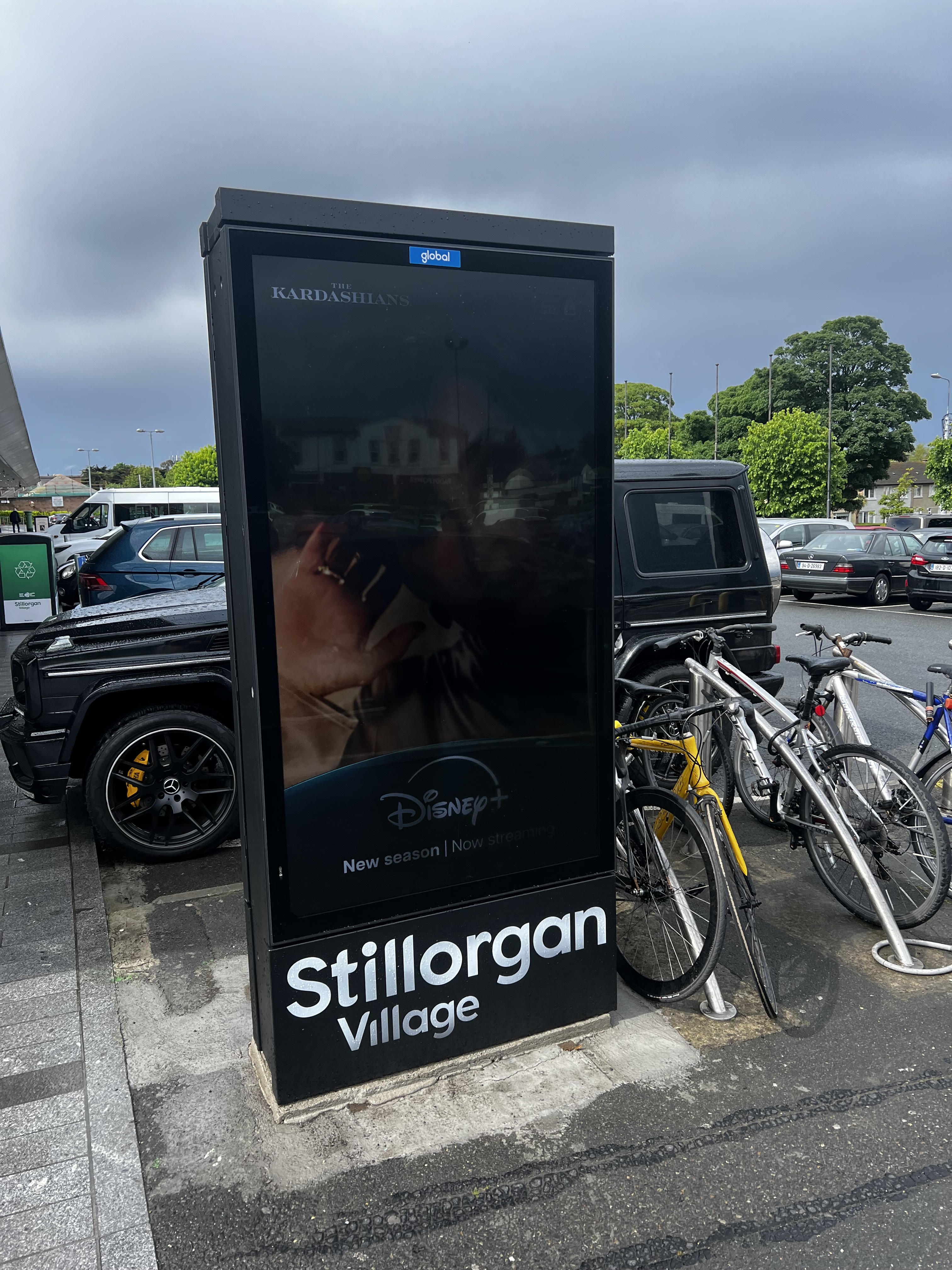
I’m referring to the advertising/digital display. I thought of using man_made=advertising + advertising=* but not of the examples on the wiki seemed to match very well.

EDIT:

I feel like an idiot for missing this but I found advertising=screen (1) after posting this

EDIT 2: Fixed the examples link

135


Edit: ~~the problem is gone, i assume it was a buggy track.~~ The problem exists with the versio 4.7.10, from 24.04.24, which is the version that is recommended by fdroid. It is gone in the latest one from 14.05.24

I updated osmand to 4.7.10 yesterday and now it seems like the little info widget on the bottom screen shows elevation (i assume), relative to the whole track, not the 10km that are currently shown in the widget. Cannot find anything in the settings. In the what's new it said they did some changes to the graphs but i could not make sense of it.

Does anybody know how i can set it back to the way it used to be, as in relative to current section of the track?

136
137


People are editing OSM to be able to get their Pokémon and others are changing OSM to mess with people so they can't get them

138


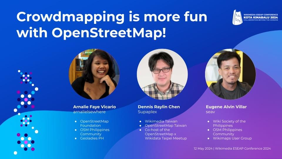
We are bringing @openstreetmap to #Wikimedia East, Southeast Asia & Pacific (ESEAP) 2024! 🗺️✈️🌏🇲🇾

Join us on Sunday, 12 May, 11AM at Mahua 1 Room to learn how to map in #openstreetmap + link #wikidata!

Full program here: https://meta.wikimedia.org/wiki/ESEAP_Conference_2024/Programme

#eseapconference2024 #ESEAP #ESEAP2024 #ESEAPKK24 #WikimediaESEAP #WikimediaESEAP2024 @seav @Supaplex

139


Recently the city redesigned the street and prepared at least 4 bus stops. The stops all have the road markings and tactile paving, etc. but no bus stop signs yet and currently no line stops there. (There is an ongoing reorganization of bus lines in my area.)

The wiki page describes how to map a bus stop and I can follow along. Everything except the line(s) and the names is local knowledge.

How should those be mapped (if at all)? Map what’s known already and add construction:bus_stop?

140
141
51
Beware of Fake Beaches (community.openstreetmap.org)


Overpass Query:

[timeout:240]
[bbox:{{bbox}}];
(
   way[natural=beach](newer:"2024-04-23T00:00:00Z");
);
out body;
>;
out skel qt;

post has been crossposted since the original did not federate correctly with lemmy.ml

142


StreetComplete is an easy to use editor of OpenStreetMap data available for Android. It can be used without any OpenStreetMap-specific knowledge. It asks simple questions, with answers directly used to edit and improve OpenStreetMap data. The app is aimed at users who do not know anything about OSM tagging schemes but still want to contribute to OpenStreetMap.

143
144
145


To connect simply run:

telnet mapscii.me
146
147


I wonder how many I have already mapped.

148


Pretty cool idea by using open street maps you can download the location you want and play the game there, defend your neighborhood or loot your house.

The reviews seem decent but mention it needs a lot of tweaking as it just released on early access, like water not affecting where zombies can walk or elevation not being a thing.

Maybe this can get some more people interested in mapping

149


2004: OpenStreetMap is founded because Ordnance Survey won’t make their data open

2024: Ordnance Survey now publishes its data in OpenStreetMap format because that’s what people expect

-- Richard Fairhurst @richardf

150


Convert your OpenStreetMap-based application links into Google Maps, Apple Maps or other links (and vice versa) without having to use proprietary software!

osm2gmaps converts links from applications like Organic Maps or OSMand to proprietary maps links, like Google Maps or Apple Maps. Just copy the link and share it to osm2gmaps or copy and paste it inside the app, it will automatically convert the link to your chosen type and copy it to the clipboard.

view more: ‹ prev next ›