
I recently installed Streetcomplete. Haven't tried it extensively yet, but so far it seems like a fun way to add missing data to OSM!
this post was submitted on 07 Aug 2024
35 points (100.0% liked)
OpenStreetMap community
5588 readers
36 users here now
Everything #OpenStreetMap related is welcome: software releases, showing of your work, questions about how to tag something, as long as it has to do with OpenStreetMap or OpenStreetMap-related software.
OpenStreetMap is a map of the world, created by people like you and free to use under an open license.
Join OpenStreetMap and start mapping: https://www.openstreetmap.org/.
There are many communication channels about OSM, many organized around a certain country or region. Discover them on https://openstreetmap.community/
https://mapcomplete.org/ is an easy-to-use website to view, edit and add points (such as shops, restaurants and others)
https://learnosm.org/en/ has a lot of information for beginners too.
founded 6 years ago
MODERATORS
I use iD editor almost every time. It's simple to use and I can use it on nearly any computer I have access to. usually put on a podcast for 30min-1h and map while I listen.
On my phone I have Vespucci installed. It's a lot slower going compared to PC but it can scratch the itch when I'm bored out and about. I use OSMand for actually using the map data.
Street Complete is slick and makes it easy to add a ton of stuff but that is geared towards polishing up the unknown details of stuff that is already mapped. I'd rather finish adding unmapped roads and sidewalks than telling OSM what materials they're made of.
I like to map land use. I spent some time on a volunteer fire department and working with their K9 Search and Rescue team on real calls and training. Land nav and good mapping is super important to them so I put some extra effort to make it as useful as possible.
It mildly annoys me when mappers add big sections of natual wood but completely ignore the big swampy wetland or other obvious things within that area like ponds. I think some people map it just so it looks nice but a little detail matters when you're there in person and have to get around.
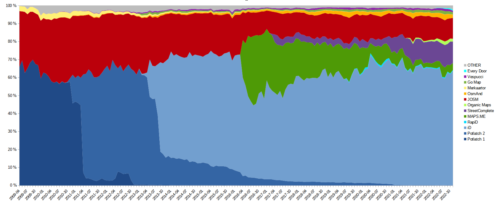
Wiki has a huge article about editor usage statistics: https://wiki.openstreetmap.org/wiki/Editor_usage_stats
Also a lot of stats here, with up to date graphs: https://piebro.github.io/openstreetmap-statistics/#eb30
TLDR:
You can see your personal editor usage statistics on https://hdyc.neis-one.org This is mine:

@infeeeee @Tyoda @openstreetmap
My hdyc pie chart doesn't show: "Could not draw pie with labels contained inside canvas".
List-wise: JOSM, StreetComplete, OsmAnd, Potlatch, Vespucci, iD, JOSM (Reverter), MapComplete, Pic4Review and then the ones that are under 10.
Is this you? https://hdyc.neis-one.org/?InsertUser I think the problem is on your end, I can see your chart. Maybe you block some script required to draw that? It's drawn by the frontend.
Weird, so that's just a Firefox thing then.
I'm using Firefox with strict protection policy with Ublock Origin on Linux, so it's not a general Firefox thing, I would consult the browser console, or maybe check if it's still not visible in a private window and without addons.
I like JOSM. It's complicated but I started with easy things and slowly grew my knowledge of the software. Now it's quite easy to hop on for a few minutes at a time to an hour or two adding whole neighborhoods.
OSM browser editor and Go Map!!! on my iPhone. I mostly do what interests me (bike parking, pedestrian/bike trails, etc.) but sometimes I work on more general stuff.
I use or have used, depending on the situation, JOSM, OsmAnd~, Ever Door, StreetComplete and Vespucci.
If I'm out and about and have a second I will contribute whatever I can, even if it isn't useful to me. I have not, however, stepped up my game and started mapping trees or fire hydrants.
removed
@Tyoda Organic maps
I use that one for finding stuff, but I had no idea you could also add places with it! The interface actually seems pretty decent!
Keep in mind that Organic Maps is mainly a navigation tool. Their data source is up to a month outdated and things you map with it could be already mapped in the source but not updated in OM.
Usually iD, but sometimes Vespucci and JOSM (I use it when I have som GPS data alongside).