
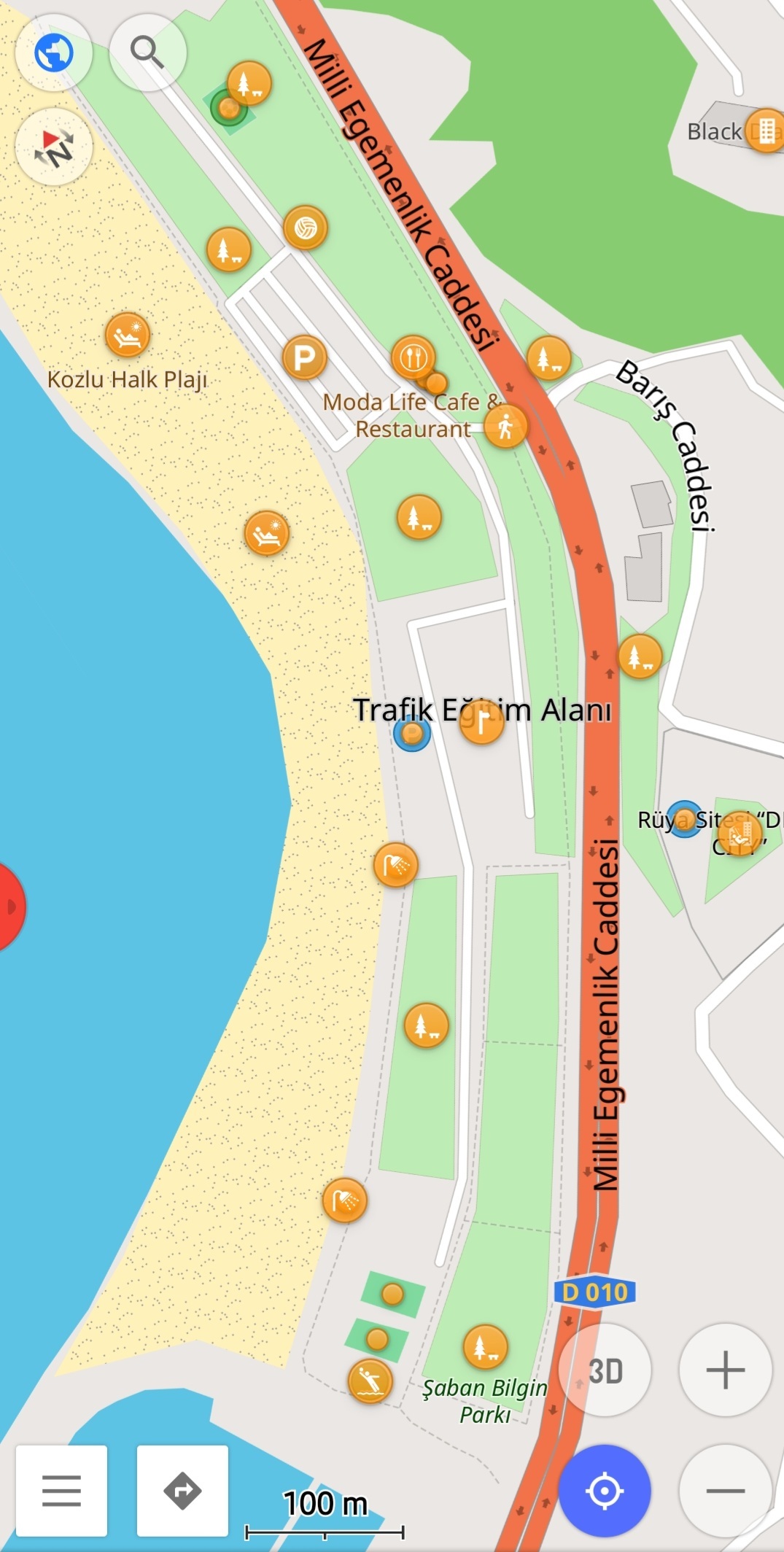
It hasn't been a week since I met OSM and Osmand. And I created all the beaches in a city from scratch. I added the important points in detail with their labels. I took long walks and it was fun.
Everything #OpenStreetMap related is welcome: software releases, showing of your work, questions about how to tag something, as long as it has to do with OpenStreetMap or OpenStreetMap-related software.
OpenStreetMap is a map of the world, created by people like you and free to use under an open license.
Join OpenStreetMap and start mapping: https://www.openstreetmap.org/.
There are many communication channels about OSM, many organized around a certain country or region. Discover them on https://openstreetmap.community/
https://mapcomplete.org/ is an easy-to-use website to view, edit and add points (such as shops, restaurants and others)
https://learnosm.org/en/ has a lot of information for beginners too.
It hasn't been a week since I met OSM and Osmand. And I created all the beaches in a city from scratch. I added the important points in detail with their labels. I took long walks and it was fun.
Nice job! It's not that hard to find where you worked if you include some text, it's here: https://www.osm.org/#map=17/41.44296/31.74970
Some tips:
place=locality tag on this thing is wrong: https://www.openstreetmap.org/way/1302651829 I can't figure out what is that from the aerial imagery, but locality in osm terminology is something different:The place=locality tag is used to name an unpopulated location for which there is no extant feature to which the tag could be associated.
Maybe the translation is wrong in the editor for this item, I see you used Turkish language. If it's some kind of an empty plaza or paved place, use place=square (wiki) or highway=pedestrian + area=yes: a hard-surfaced, open pedestrian area: https://wiki.openstreetmap.org/wiki/Square
These are small problems, it's really nice, keep up the good work!
It's also recommended to reach out to the local community, they can help a lot. You can find your official channels on this site for any place of the World: https://openstreetmap.community/?map=36.94533,34.03161&zoom=5.52
Thanks for the tips. I will be better soon.
You are already in the top 40 in Turkey: https://osmstats.neis-one.org/?item=countries&country=Turkey
See your stats here: https://hdyc.neis-one.org/?Alpagun
Wow, I didn't know there was such a statistics page. It's nice. Thanks
I downloaded this after seeing it on lemmy a few weeks ago. I think I'm the only person using it in my town.
Have a look at StreetComplete while you're at it
Thank you!
Nice work!
Really need that Wigglett, huh?
What is the wigglett?
Pokemon GO recently introduced a new Pokemon from the Scarlet/Violet games, Wigglett. It only spawns in areas designated as beaches, and Pokemon GO primarily sources its map data from OSM. A lot of people don't have many beaches nearby, making it a pretty rare Pokemon.
Wow I get it.
Thanks for your contribution 🙏
You're going to love StreetComplete.
Edit: https://streetcomplete.app/ and yes, it's FOSS.
Yes it's very good
Very cool, I'm sure people will appreciate your contributions when they use the information :)
I am very tired and jesus fuck I read you made all the benches
Plot twist they live in Denver
Why would it be a plot twist, it's called armchair mapping, and the most common way of mapping
I have some random spots in the world where I draw buildings and paths regularly. I have no irl connection with them, I just randomly zoomed there once and bookmarked it. There is something relaxing, zen like feeling when you just trace houses and paths. Never intend to go there, but it's nice to create something. Maybe one day a guy will wonder who the hell draw his village in South Kongo, and why is it much more detailed than the regional capital
There are no beaches in Denver
There are 4 beaches mapped in Denver: https://overpass-turbo.eu/s/1OEQ
*smile widens fearfully, and head shakes imperceptibly left and right*
Nice one, OP!
The most annoying thing when adding POIs with Osmand for me is, that the POIs are disappearing when uploaded.
The POIs are only coming back after map update which takes couple of days or weeks.
That means its impossible fix an error on the new POI. Another editor needs to be used then. I use Vespucci in these cases.