this post was submitted on 30 Jul 2025
371 points (98.9% liked)

xkcd

13317 readers
20 users here now

A community for a webcomic of romance, sarcasm, math, and language.

founded 2 years ago
MODERATORS
 

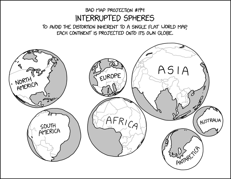
xkcd #3122: Bad Map Projection: Interrupted Spheres

Title text:

During the most recent glacial maximum, it's believed that land bridges extended from the surfaces and connected several of the spheres together.

Transcript:

Transcript will show once it’s been added to explainxkcd.com

Source: https://xkcd.com/3122/

explainxkcd for #3122

top 37 comments
sorted by: hot top controversial new old
[–] eth0slash0@sh.itjust.works 31 points 2 months ago (3 children)

!mapswithoutnz

Aww it's not a community (yet?)

[–] SkaveRat@discuss.tchncs.de 5 points 2 months ago

!lemmywithoutmapswithoutnz

[–] Appoxo@lemmy.dbzer0.com 3 points 2 months ago

And without the Arab countries like the UAE

[–] FlihpFlorp@piefed.zip 1 points 2 months ago* (last edited 2 months ago)

Well I think you need to add the instance name too

!lemmy.ca/c/helldivers2

Edit: wait no I didn’t do it right either

[–] sanguinepar@lemmy.world 30 points 2 months ago (1 children)

I actually kind of like this as a concept for showing the world!

[–] chtk@feddit.nl 60 points 2 months ago (2 children)

I like how the globe for Australia keeps the trend of not including New Zealand going.

[–] sanguinepar@lemmy.world 6 points 2 months ago (1 children)
[–] Zachariah@lemmy.world 12 points 2 months ago

so did the cartographer

[–] FireWire400@lemmy.world 4 points 2 months ago (1 children)

I mean, NZ would be its own globe because it's a separate country.

But the Australia globe is potentially missing Tasmania.

[–] msfroh@lemmy.ca 2 points 2 months ago* (last edited 2 months ago) (1 children)

Is it its own continent? Because each sphere is a continent.

[–] FireWire400@lemmy.world 2 points 2 months ago

Doesn't it have to be if it's an island? I feel pretty stupid right now lol

[–] ksigley@lemmy.world 14 points 2 months ago

There really is an xkcd for everything.

[–] sga@lemmings.world 8 points 2 months ago

this is actually very close to pseudocylindrical projections (an example is the orange peal like sliced maps, wiki says its called Goode homolosine). they look wierd, are dicontinous, but still largely preserve area and angles.

this one is very similar, except sizes are still wierd, and uses different radii spheres, which makes it both non angle and size preserving.

[–] angrystego@lemmy.world 2 points 2 months ago

Cartographers might try to tell you the continents on these maps are distorted - but it's just their projection!